|
|
|
April 2001
All Photos © Tim N. Touchton
This web site is designed to be viewed if you maximize your window.
The pages may take a few moments to load the first time.
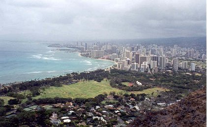
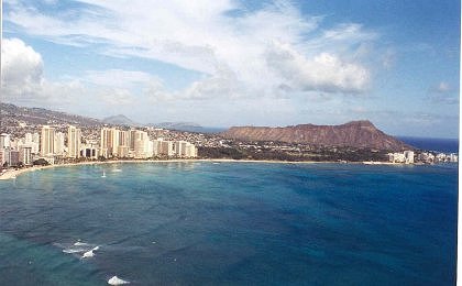 This
is a photograph I took from the Rainbow Pacific helicopter tour I
This
is a photograph I took from the Rainbow Pacific helicopter tour I
took. I got to ride in the copilots seat and they discounted my admission
because none of my sons were "brave" enough to ride with me. I had
two 75
year old women riding in the back seat of the helicopter.. It was a great
trip, but rather windy in parts. I wish the pilot had gone around Diamond
Head
Crater on the seaward side though because it would have made a much better
picture below.
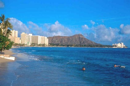
Taken from the beach close to the Outrigger Reef Hotel.
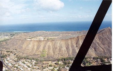
This was taken from the Rainbow helicopter tour also. The helicopter got
in the way for a better shot. I also took a photograph of the inside of the
crater
when my son (Richard) and I hiked up Diamond Head to the Lookout. I had to
use ASA400 film because I wasn't sure what the weather would be like and the
movement of the helicopter and the shaking motion. I also shot about 27 minutes
of digital video. I had to fight the glare on the windows the entire time.
These are the "FINAL" stairs that you have to go
up before the last tunnel and the spiral staircase.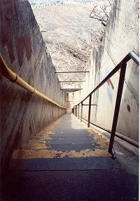
It's about a 1.25 mile hike from the parking lot to the summit and is rather
slippery and rough in spots. It's the original (1908) trail for mule and foot.
It's mostly trail, but there are 2 sets of stairs and a very dark tunnel also.
After all this you have to climb a 4 step ladder and maneuver through
a "gun turret" opening which is very small and then to the final
lookout on top of the crater. It is a tight fit and seems to be very crowded
often. On the day we went to the top it was very cloudy and the view wasn't
that great. See below.........a blah sky. I also had to carry my
video and Canon 35mm equipment, which consists of 2 full size bags, and a
fanny pack for water bottles. I had Rich carry my very heavy tripod
on this hike. This view is looking down. Richard slid all the way down these
on the right side where the water "culvert" is. About half way down
he
clunked his head on a cross railing. (Ha Ha) He ended up heating up the bottom
of his shoes sliding down this. It was pretty awesome those and
several people laughed watching him. He definitely beat me down the stairs.
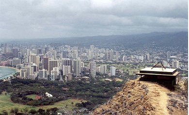
This is a view of Waikiki from the lookout on top of the Diamond Head
Crater. Boy I wish we did this on a pretty day, but we ended up with two
days of very cloudy and somewhat rainy weather and the other four days
were very beautiful. I had a schedule and the weather just didn't work this
day.
This almost looks like it could have been taken from the helicopter, but it
wasn't.
The water is crystal clear along the coast, but due to the overcast conditions
you
cannot tell in this photograph. You are looking towards Wai'anae past the
buildings of Waikiki.
This is a photograph looking down inside of the crater from
the lookout.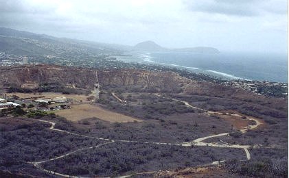
You can see Koko Head Crater off in the distance and just to the right of
it is Hanauma Bay. I really wish I had pretty blue skies this day. This shot
would
have been magnificent if I had clear blue skies. Just past the Koko Head Crater
is the Makapu'u Lighthouse. There is a tunnel you drive through to get inside
the crater to the visitor area. The parking and entrance to the crater and
trail is free. Plan on about 1 1/2 hours to go from the parking lot to the
lookout
and back to the parking lot.
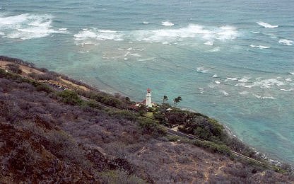
A view of the famous Diamond Head Lighthouse from the top observation
area of the Diamond Head Crater. I used my regular Canon 28mm lens for
this shot to show "height". On my Diamond Head Lighthouse
page you'll
see a close up from this same angle using my Canon 100-300mm USM lens.
You can easily see the reef around the island from this vantage point.
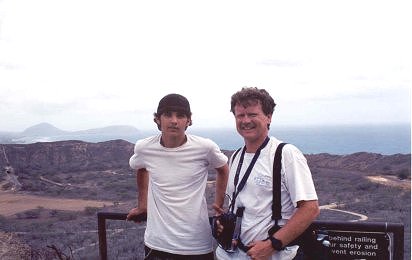 Here's
me and Rich at a spot where the military had a winch and cable
Here's
me and Rich at a spot where the military had a winch and cable
to haul up supplies and materials to the summit. We are just outside of the
last set of steep stairs before the last tunnel and the spiral staircase to
the battery and the outside observation area. You can see Koko Head Crater
in the far background.

Rich at the final top observation area with
Waikiki in the background.
Diamond Head, located on the Southeast Coast of O'ahu, by Waikiki, was originally
named Le'ahi by ancient Hawaiians.
The name meant "brow of the tuna" and looking at the side silhouette
of the crater from Waikiki, it does look like it. The current
name of Diamond Head was given to the crater by British sailors in the 1800's
because when they saw it from a long distance
the calcite crystals in the lava rock glimmered in the sun. The British sailors
thought that they must be diamonds in the soil and rock.
The crater is 3,520 feet in diameter and has a 760 foot high summit.
Information about Diamond Head
The pronounced seaward summit, deeply eroded
ridges, and the ovid-shaped crater are evidence of Le'ahi's very dynamic geological
history.
The Ko'olau and Wai'anea Mountain Ranges are the remnants of very eroded volcanoes.
When the southeastern end of the Ko'olau Range
erupted, these eruptions occurred near the ocean where the magma was broken
down into ash and fine particles by the water and steam. Blown
into the air, these particles were cemented together into a rock called tuff,
which created tuff cones, such as Le'ahi.
The broad saucer-shaped
crater covers 350 acres with its width being greater than its height. The
southwestern rim is the highest because winds were blowing ash in this
direction during the eruption. The slopes of the crater have been eroded and
weathered by rain, wind, and the pounding surf. A coral reef now
protects the seaward slopes of the crater. Today Le'ahi (Diamond Head) is
the most recognized landmark in Hawaii. It was designated a National
Landmark in 1968 as an excellent example of a tuff cone. Up until the early
1900's, rainwater collected on the crater floor created a small lake for
native ducks, coots, and gallinules.
The military history of Diamond Head
goes back a long time. Fires used to be lit along the base/shoreline as navigational
aids to Hawaiians.
In 1904 it was purchased by the Federal government and designated for military
use. Fortifications began in 1908 with the construction of
gun emplacements and an entry tunnel built through the north wall of the crater
from Fort Ruger, known as the Kapahulu Tunnel. A total of
5 batteries were built at the crater: Harlow (1910) on the northern exterior,
Dodge and Hulings (1913) which tunnel through the eastern wall,
Birkhimer (1916) which is largely below ground inside the crater, and Battery
407 (1943) which tunnels through the southern wall. Fire Control
Station Diamond Head was built at the summit between 1908-1910 and housed
instruments and plotting rooms to direct artillery fire from the
batteries. From this observation station, you could triangulate targets and
aim the mortar fire from Batteries Randolph and Dudley at Fort DeRussy
in Waikiki and Battery Harlow at Fort Ruger on the outer slopes of the crater.
The exterior of the Fire Control Station was camouflaged with
rubble embedded in concrete. Additional coastal defense was provided by long
range guns installed on the outer slopes and rim of the crater in 1915.
The trail to the summit was built in
1908 as part of the U.S. Army Coastal Artillery defense system. The trail
scaled the steep interior western
slopes of the crater to the summit. It was designed as a dirt trail for foot
and mule traffic with numerous switchbacks. Some materials/supplies were
hosted from the crater floor by winch and cable to a point along the trail.
(See the photograph of me and Richard, we are at that spot.)
There are two foot tunnels, two sets of steps, spiral stairs
and ladder, all after the dirt trail. You'll come to a steep stairway of 74
concrete steps leading to the first tunnel. Then you go through a dark passage
of a 225 foot long narrow tunnel. After the first tunnel
you will come to a second stairway consisting of 99 steep steps. The cross
beams above these steps supported camouflaging.
After the second set of steps you come to a short tunnel at the base of the
Fire Control Station. Then you come to a metal spiral
staircase for "4 levels". The 54 metal stairs replaced the ladder
to the summit in the 1970's for hiker safety reasons.
This is one of the bunker/gun emplacements beside the Fire Control Station.
Directions:
From Waikiki to the east on Kalakaua Road. You'll go along the beach front
and the beautiful Kapiolani park. You drive beside the
Honolulu Zoo on your left and turn left onto Monsarrat Avenue. Continue on
Monsarrat until it turns into Diamond Head Road. Stay
on Diamond Head Road and you'll go around the crater and then come to the
entrance (the tunnel) into the crater on your right. There
are subdivisions all around this part of the Diamond Head Crater.
Back to My O'ahu Trip Main Page
COPYRIGHT INFORMATION
- All of the photographic images in this web
site as well as all of the written content in this web site are protected
by copyright and are not offered for commercial, public or personal use without
prior written consent. Please do not copy and/or distribute the images or
the written
content contained in this web site in print or digital form. Distributing
images
or the written content from this web site may put you or others at risk for
copyright violations.