|
|
|
"The Curved Bay"
April 26, 27, 29 2001
All Photos © Tim N. Touchton
This web site is designed to be viewed if you maximize your
window.
The pages may take a few moments to load the first time.

This is Hanauma Bay, simply beautiful!

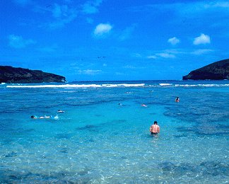
You can see Rich in the middle of the left photograph coming out of the water
with his mask, snorkel and swimfins.
In the photograph of the right you can see Rich snorkeling in the dead center
of the photograph. Notice the two helicopters
in the right photograph. These first 3 photographs were taken with slide film,
the rest at Hanauma Bay were on print film.
Hanauma Bay was once an active volcano. One side of the rim
collapsed and allowed the sea to enter and soon a reef
came to life creating this paradise for snorkelers from all across the world.
The bay was declared a protected marine life
conservation area and underwater park in 1967. This is the best place on the
islands for snorkeling and scuba diving to see
a large diversified fish population on a beautiful reef. The park is closed
every Tuesday to give the reef time to recuperate.
It costs $1 per car for parking and $3 per person for admission (for those 13
years old and older). There are lifeguards on
duty, restrooms, beach area and snorkel gear rental.
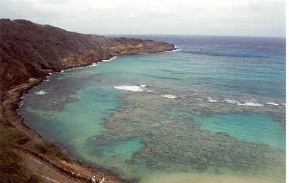
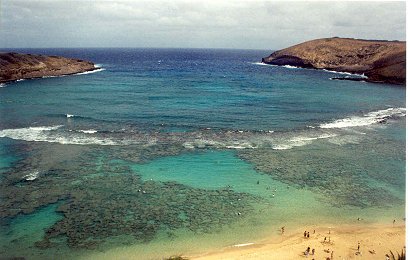
On the left photograph you can see the area where Rich and spent most of our
time. The open area to the left in the left photo is where we
snorkeled most of the time. We would go along the edge of the reef and also
up on the reef on the far left. There would be a lot of fish along
this area because not that many people would snorkel up in that shallow of water.
Most people would swim in the center sand area, as seen in
the right photo, in the middle. Off to the left on each photograph is the famous
"Toilet Bowl". It's at the far tip, but was closed each day that we
were there. If the sea is too rough then the Toilet Bowl is closed, for the
safety of the visitors. In the right photograph the piece of thin land coming
out is called the "Witches Brew". You can take some great photographs
of waves as they hit hard against the rocks here. On our first day here it
was open, but the next time it was closed due to the seas being too rough. The
first day we took some photographs (but I screwed up the film) and
we double exposed them all. Rich took some photographs of the waves as they
splashed high above my head and just behind me. Too bad.
Click here for more pictures!! Please do.
Directions:
Take H1 east which turns into Kalanianaole Highway. There
are signs everywhere which direct you to Hanauma Bay
from Waikiki. Hanauma Bay is on the right and you cannot miss it. Koko Head
Crater is just off to the left past Hanauma
Bay. The Halona Blowhole and Sandy Beach is off to the right just past Hanauma
Bay also.
COPYRIGHT INFORMATION
- All of the photographic images in this web
site as well as all of the written content in this web site are protected
by copyright and are not offered for commercial, public or personal use without
prior written consent. Please do not copy and/or distribute the images or the
written
content contained in this web site in print or digital form. Distributing images
or the written content from this web site may put you or others at risk for
copyright violations.